Another winter storm is spreading across Ontario and Quebec Friday evening through to Sunday, with heavy snowfall and extreme winds expected to produce road hazards and up to 30 centimetres of snow in some regions.
“We’re talking about a system that is slowly edging its way into Ontario and Quebec,” said Environment Canada meteorologist Gerald Cheng during a virtual media availability held on Friday. “It’s already affecting much of the Midwest, and much of the southern U.S. as well.”
Cheng says snowfall warnings were issued in southern Quebec, along with a winter storm warning for Ottawa, north of the Ottawa Valley and areas near Lake Huron.
“We also have special weather statements from Quebec City all the way to far-eastern Quebec,” he said. “We still have a winter weather travel advisory for areas along the shores of Lake Ontario towards London and also for areas in northeastern Ontario, including Timmins.”
Cheng added that alerts will likely change as the weather system evolves.
“The snow is also accompanied by strong winds. We’re seeing gusts up to 70 km per hour. So, combined with the snow, that will cause very, very dangerous conditions on the roads. It’s certainly not a great time to travel.”
ONTARIO
In areas around Lake Huron, “we’re talking about up to 25 centimetres of snow. Today plus tomorrow,” he said.
“Ottawa, you’re not going to get into the snow until really Saturday, and we’re talking about up to 25 centimetres of snow,” Cheng added. The Greater Toronto Area is expected to receive five to 10 centimetres of snow.
A winter storm warning issued for Toronto Friday evening said the city could receive as much as 25 cm of snow.
Toronto police have advised drivers to slow down and drive according to the weather conditions.
Ontario Provincial Police also warned of the potential for a “significant accumulation of snow,” which could turn into rain overnight.
QUEBEC
The Quebec City area is expected to get the brunt of the storm surge, as well as areas along the Gulf of St. Lawrence.
There are also risks of coastal flooding. “Check your local forecast to ensure that you are prepared for it,” cautioned Environment Canada.
Cheng also said that the problem extends far beyond heavy snowfall.
“It’s also about the winds,” he said. “The winds will be howling quite greatly, quite fiercely, and it will be gusting up to 100 km per hour in some places on Saturday, including Saturday night.”
Cheng warned that conditions will likely lead to dangerous driving conditions.
“Be careful of the whiteout conditions,” he said.
Environment Canada meteorologist Jean-Philippe Begin added road conditions will be difficult in some places, however Quebecers can expect less rain this time around.
“Of course a little bit of rain makes a risk of freezing rain but we are not expecting a lot of impact with this transition, and with cooling temperatures behind, everything will freeze again. So similar impacts although we expect less rain this time, yes. So road conditions and on sidewalks, everywhere is going to be slippery,” Begin said.
STORM CHRONOLOGY
Environment Canada warns that storm surges will affect southwestern Ontario by Friday evening, also impacting the Greater Golden Horseshoe Area.
“As we head into midnight, it will also affect Ottawa, Montreal, and back towards much of northeastern Ontario,” Cheng said.
By Saturday morning, in southern Quebec,Montreal and Quebec City will likely get heavy snowfall.
“Back in southwestern Ontario, and Greater Golden Horseshoe, some of that warm air from the system might come in to melt the snow a little bit.”
Cheng said that Saturday afternoon will bring sweeps of cold air and more snow will hit southern Ontario. “But it will also be easing from east to west, still snowing for Ottawa, Montreal, and Quebec City.”
By Saturday evening, the storm should wind down in southern Ontario, said Cheng. “However the winds will be picking up during the day on Saturday, so (that’s) something to be mindful of with freshly fallen snow.”
After blanking large swaths of Ontario and Quebec, snowfall systems are expected to shifteast into Atlantic Canada.
“On Sunday, it really winds down everywhere for southern Ontario, except if you’re really on the east side of the Great Lakes because the winds are coming out of the northwest,” he said.
WEATHER WARNINGS
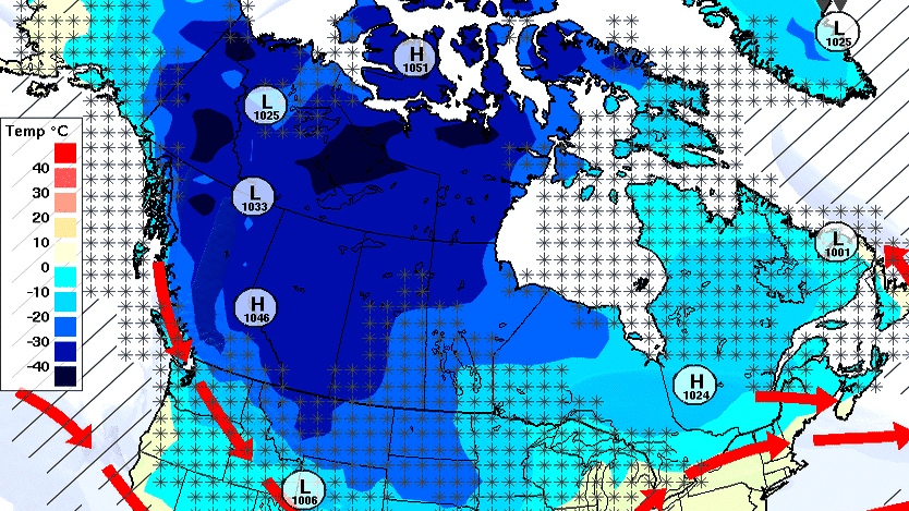
Environment Canada issued weather warnings, statements and watches in every province and territory across the country on Friday morning.
Extreme cold is an issue on the West Coast, in the Prairies and in northern Canada, where it may feel as cold as -55.
And heading into the weekend, Canadians in Ontario, Quebec and the Maritimes should prepare for another major snowstorm, which could bring up to 30 centimetres of snow in some areas.
Getting colder
An arctic airmass moved into Alberta, Saskatchewan and portions of Manitoba, Yukon and the Northwest Territories earlier this week, bringing with it bitterly cold temperatures that remained in place on Friday.
The parts of the affected region seeing the coldest temperatures are noting a mercury drop between -35 C and -40 C on Friday, but with wind chill values it may feel as cold as -50.
Environment Canada issued extreme cold warnings earlier this week, which were renewed Friday and expected to stay in place until at least Saturday morning.
The weather agency said temperatures will continue to drop over Saturday and into Sunday, with the latter part of the weekend being the coldest.
Some places in Alberta, northern Saskatchewan and parts of Yukon could feel as cold as -55 over the weekend.
More winter weather is expected across the country on Friday and into the weekend, with some Canadians preparing for snow and others bracing against bone-chilling wind.
The entire provinces of Alberta and Saskatchewan are under the same extreme cold warning, whereas Manitoba and the territories are under alerts specific to some areas.
Temperatures in the southern halves of Saskatchewan and Manitoba could feel as cool as -40 to -50, Environment Canada says.
Coral Harbour, Nunavut, can expect blizzard conditions due to strong winds from Friday through Saturday. This portion of the territory is the only one with an alert from Environment Canada.
West Coast warnings
B.C. has a smattering of weather warnings in effect Friday morning.
The province’s coastal sections are under an arctic outflow warning, meaning people in these areas could experience wind chill values near -20 to -30 even in areas where the weather is usually mild, like Victoria and Metro Vancouver, according to Environment Canada.
Wind chill values could “moderate” this weekend for the coastal portions of the province, and Environment Canada did not say when it would warm up.
For the Lakes District, it’s forecast to feel as cold as -40 to -50 – wind chill values that are expected to last into Saturday. Environment Canada says temperatures will moderate by Sunday.
The eastern side of Vancouver Island is under a snowfall warning from the weather agency, with five to 10 centimetres possible through Friday morning.
30 cm of snow
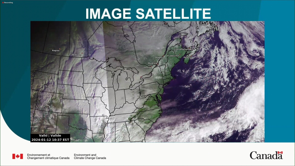
A second Texas low storm system is looming over the eastern half of the country on Friday morning, Environment Canada’s weather warnings, advisories and watches showed.
Much of southern and eastern Ontario is under a winter storm warning Friday due to a storm not expected to land until this evening.
Environment Canada warns as much as 25 centimetres of snow is forecast for parts of Ontario including Southern Grey County and the Ottawa Valley Friday afternoon and into the evening.
The agency warned that this snow could fall as rapidly as three to five centimetres per hour.
Further north, snow totals for the Greater Sudbury area and surrounding regions could have higher accumulation amounts nearing 30 centimetres of snow.
Heading east, “strong winds and blowing snow” should be expected in western and central Quebec, Environment Canada said.

Some areas could see up to 20 centimetres of snow.
Further north, Environment Canada issued a special weather statement for communities north of Montreal warning of “significant snowfall” on Saturday.
Another weather statement applies to most of New Brunswick, P.E.I. and Nova Scotia, and also warns of the incoming system.
New Brunswick and P.E.I. are likely to see snow, Environment Canada said, but the precipitation is expected to fall as 25 millimetres of rain in Nova Scotia.
Labrador City and Wabush, N.L., are under a winter storm watch from Environment Canada for Saturday night into Sunday evening.
It’s expected that 20 centimetres of snow and 70 km/h winds will reduce visibility across this portion of the province. As of 7 a.m., no warnings had been issued for the rest of the province.
Environment Canada said conditions are expected to improve by Sunday afternoon.
